

Looking Beyond the Count: How Drones Are Changing the Way We Monitor Cliff-Nesting Seabirds
Written in anticipation of CIEEM’s 2026 Scotland Conference, Fieldwork Futures: Innovations in Ecological Practice, where James Bunyan MCIEEM of Tracks Ecology Ltd and Grant Humphries of Black Bawks Data Science Ltd will be further exploring this topic.
Every breeding season, teams of ecologists head to some of the UK’s most spectacular—and challenging—coastlines to monitor internationally important seabird colonies. These surveys provide the baseline information needed to understand how populations are changing over time and to assess the potential impacts of developments such as offshore wind farms.
For decades, these surveys have relied on combinations of land-based observations and boat-based counts. While these methods have provided invaluable datasets, they can also be expensive, weather-dependent, difficult to repeat consistently and, in some locations, simply challenging to undertake safely.
Over the last two years, colleagues from Tracks Ecology Ltd and Black Bawks Data Science have been exploring how drone technology can complement these traditional approaches. At the forthcoming CIEEM Scotland Conference, we’ll be sharing what we’ve learned—from field trials and workflow development through to some exciting opportunities that extend well beyond simply counting birds.
Working safely around inaccessible colonies
Our work has taken place within the East and North Caithness Cliffs Special Protection Areas (SPAs) under licence from NatureScot. These dramatic cliffs support internationally important breeding populations of species including guillemots, razorbills and kittiwakes.
Cliff environments present unique challenges for ecological surveyors. Colonies can extend for many kilometres, birds occupy narrow ledges at varying heights, and access is often impossible. Boat-based surveys can offer excellent viewing opportunities but are dependent on sea conditions, while land-based counts can be limited by viewing angles and the distance between observer and colony.
Our initial trials in 2024 used a DJI Matrice 30T to test a high-resolution imaging workflow. Rather than relying on single photographs, we developed a systematic grid-based image capture approach that produced extremely high-resolution composite images of entire cliff sections.
During the 2025 breeding season we refined this approach further using a DJI Matrice 350 RTK equipped with an H30 camera. The improved optical zoom allowed surveys to be undertaken from greater stand-off distances, reducing the likelihood of disturbing breeding birds while also improving operational safety for the flight team.
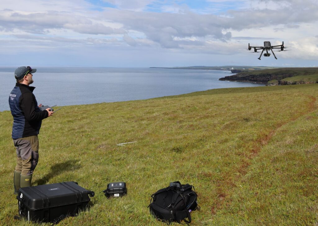
Figure 1: Grant Humphries flying the DJI Matrice 350 RTK surveying a cliff colony.
Seeing more than the human eye
One of the most encouraging outcomes has been the quality of imagery that can now be collected.
Unlike traditional field observations, every section of cliff is permanently recorded, allowing images to be reviewed multiple times, independently verified and archived for future reference. This provides a level of visual auditability that is difficult to achieve with field counts alone.
When we compared UAV imagery with traditional boat-based counts for selected cliff sections, we found that drone imagery identified, on average, around 36% more guillemots, while counts of razorbills and kittiwakes were broadly comparable between the two approaches.
These differences don’t necessarily mean that historical methods were inaccurate. Rather, the ability to zoom into high-resolution imagery repeatedly allows observers to identify birds occupying narrow ledges or partially obscured positions that may be difficult to distinguish during a single field observation.
Perhaps more importantly, the imagery creates a permanent record that can be revisited as analytical methods continue to improve.

Figure 2: Identification and counting of guillemots (pink circles), razorbills (orange circles) and kittiwakes (blue circles) within a section of the East Caithness Cliffs SPA.
From counting birds to understanding colonies
While improving count accuracy is valuable, one of the most exciting aspects of this work is what becomes possible once every bird has a a mapped spatial location.
Rather than producing only a total count, individual birds can be mapped across an entire colony, revealing how different species use the cliff face and how those distributions change through the breeding season or between years.
As these datasets accumulate, they offer opportunities to answer ecological questions that have previously been difficult to investigate, including:
- How do breeding distributions shift between years?
- Which ledges are consistently occupied?
- How do colonies respond to environmental change?
- Are changes occurring uniformly across a colony or concentrated in particular areas?
These spatial datasets begin to move us beyond simple abundance estimates towards a richer understanding of colony dynamics.
Bringing colonies into three dimensions
The next stage of our work is looking to combine high-resolution imagery with detailed 3D models of cliff faces generated using drone photogrammetry.
Rather than viewing bird locations on a flat image, individual breeding birds can be positioned directly onto a detailed three-dimensional model of the cliff. This allows colony structure to be explored in entirely new ways.
For example, it becomes possible to investigate relationships between breeding locations and physical characteristics such as cliff height, slope, aspect or ledge geometry. Over multiple survey years, these 3D datasets may help identify subtle changes in how colonies are organised and how habitat use changes through time.
This also creates an engaging way of communicating complex ecological information to clients, regulators and stakeholders by allowing them to explore colonies interactively rather than relying solely on static figures.

Figure 3: Example 3D cliff model suitable for detailed mapping of seabird locations.
Building repeatable and transparent workflows
An important part of this project has been developing workflows that are practical for operational ecological consultancy rather than purely academic research.
Every stage—from flight planning and image acquisition through to processing, quality assurance and counting—has been refined with repeatability in mind. Standardised workflows help ensure that surveys can be reproduced consistently between years while maintaining an auditable record of both imagery and interpretation.
Although our current work focuses on cliff-nesting seabirds, many of the principles have much wider application. Similar approaches could support surveys of other inaccessible habitats where safety, repeatability and data transparency are important considerations.
UAVs are not a replacement for every established seabird survey technique. Operations remain constrained by weather, aviation requirements, site characteristics and the need to avoid disturbance, and some ecological questions will continue to require observations from land or sea.
Continuing the conversation
Drone technology is evolving rapidly, bringing improved sensors, longer stand-off distances and increasingly sophisticated analytical tools. These developments are creating opportunities not only to make ecological surveys safer and more repeatable but also to extract far more information from the data collected.
At this year’s CIEEM Scotland Conference, we’ll be sharing both the successes and the lessons learned from developing these workflows in active seabird colonies. We’ll discuss the practical realities of operating safely around breeding birds, compare drone-derived imagery with traditional survey methods, and explore how high-resolution mapping and emerging 3D analysis techniques could help shape the future of ecological monitoring.
We’re looking forward to continuing that conversation at the CIEEM Scotland Conference—sharing what we’ve learned so far, and hearing how others are using emerging technologies to answer ecological questions that were previously difficult, or even impossible, to tackle.
About the author
James Bunyan MCIEEM is Director and Principal Ecologist at Tracks Ecology Ltd, where he specialises in applying emerging technologies to ecological survey, monitoring and research. A Full Member of CIEEM with over 20 years’ ecological experience, his work combines UAVs, high-resolution imaging, thermal monitoring, remote sensing and GIS to tackle challenging ecological questions. He has a particular interest in developing practical, repeatable methods for monitoring wildlife in complex and inaccessible environments.
Photo credits
All photographs and figures: James Bunyan, Tracks Ecology Ltd.
3D visualisation and spatial analysis work developed as a collaboration between James Bunyan, Tracks Ecology Ltd. and Dr Grant Humphries, Black Bawks Data Science Ltd.