Teaching a Drone to Know a Sika from a Red: DroneWild’s Journey in Machine Learning and Wildlife
Written in anticipation of CIEEM’s 2026 Scotland Conference, Fieldwork Futures: Innovations in Ecological Practice, where Ben Harrower will be presenting on behalf of DroneWild.
A red deer and a sika deer, seen from several hundred metres up on a cold Highland hillside can look almost identical and an experienced surveyor learns to read the difference over many years. A couple of years ago we set ourselves a question: could we teach a computer to read those clues too but from a drone view – a very different challenge compared to static trail cameras!
That question grew into DroneWild’s machine learning programme. The process began through our sister company BH Wildlife Consultancy, which has flown thermal drones to survey wildlife across the UK and Europe for many years. Every survey generates thousands of images and days of manual review so we set out to train a first phase model. Our advantage was data: a database of hundreds of thousands of drone images built up over years of survey work. With the help of Addax Data Science, we began turning that archive into a training dataset, teaching the model what deer, goats and boar look like from the air, in thermal and optical across a variety of different habitats.
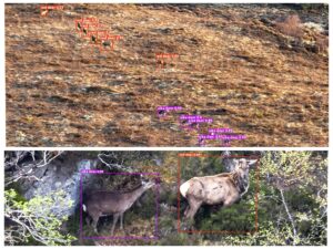
Photo 1: Wide angle showing a herd of sika and red deer on an open range. Zoomed image shows two young stags – one sika and one red stag in Atlantic rainforest habitat.
Building it up, species by species
Machine learning of this kind is a series of phases, each broadening what the model recognises. Early phases covered our core deer species, then foxes, squirrels, hares and wallabies. We are now well into Phase Three (our most ambitious) adding pine marten, wildcat and grouse alongside more goats, squirrels and boar. Phase three involves a final set of 15,000 images and videos equalling some 75,000 individual annotations. The reward is a more accurate model that has increased confidence on our existing species and added new species to the constantly growing list.
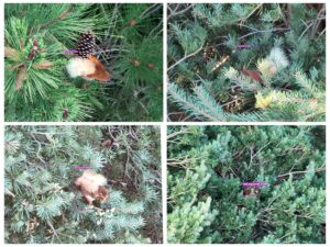
Photo 2: Examples of the model picking up red squirrel – a species added during the second phase of training.
Putting it in a practitioner’s hands
A clever model is only worthwhile if practitioners can use it, so we are delivering it two ways. The first is a web app: upload a survey’s imagery and it automatically generates annotations, distribution and density maps. This rapid process turns a series of images collected into an annotated evidence base, turning hours of review into minutes. The second is detection in the field, with the model running directly on the drone controller so a ranger gets automatic real time detections live as they fly. It isn’t perfect yet, but it points clearly to where this is heading.
Why it matters
This is not technology for its own sake. Understanding where wildlife is, in what numbers and at what density is fundamental to managing our habitats well. A thermal drone paired with a trained model will in time let us survey more ground, more accurately, with less disturbance and fewer resources. A model that reliably tells a red squirrel from a grey, for instance, could give early warning as greys move into red strongholds – autonomous drone flying is a new area that is only just starting to be explored. One example includes Network Rails recent use case deploying drone in a box for automatic autonomous flights saving countless hours of staff time. This technology doesn’t replace the ecologist, the best results come when field skill and technology work together, each catching what the other might miss.
Over the coming months we aim to launch the web app alongside Phase Three and a new online training course, now in beta testing with Forestry and Land Scotland. I’ll be talking through the journey (setbacks as well as breakthroughs) at CIEEM’s 2026 Annual Conference.
About the Author
Ben Harrower is co-founder and director of DroneWild and BH Wildlife Consultancy, both based in Edinburgh. With co-founder Katie Harrower, he has pioneered the use of thermal drones for wildlife survey across the UK and Europe since 2018. DroneWild develops thermal micro-drones, AI-enhanced software and industry training for wildlife management and conservation. Find out more at www.dronewild.co.uk.
Ben will be speaking at CIEEM’s 2026 Annual Conference.