Beyond the 100/36 standard: an evidence-based review of wind energy ornithological guidance – by Tom Gittings MCIEEM
This blog post has been written in conjunction with the 2024 Irish Conference: Examining the Practical Impacts of Environmental Policy and Legislation on Ireland’s Ecology. Tickets are available to purchase.
The development of the Irish onshore wind energy industry has generated requirements for intensive bird survey work with large wind farm projects often needing over 300 days of survey work. Ornithologists working in this industry are in the fortunate position in having a lot of detailed guidance available. Most of this guidance was developed by Scottish Natural Heritage (SNH) but it has become widely accepted as the standard for wind energy bird surveys and assessments in Ireland. SNH’s recommendations are now very influential in assessing the adequacy of bird survey work carried out for Irish wind farm projects.
Vantage point surveys are a key component of the survey work. These are carried out to collect flight activity data, which is then used to model the predicted collision risk from the development of the wind farm. The widely accepted standards derived from SNH guidance[1] are that the survey area (the viewsheds of the vantage points) should aim to cover 100% of the wind farm site, and that 36 hours of vantage point surveys should be carried out each season (the 100/36 standard). However, bird flight activity is usually highly variable across space and time. There are many decisions that are made, implicitly or explicitly, in the design of vantage point surveys that will affect the degree of bias and error in the flight activity samples that are collected. Therefore, the one size fits all approach of the 100/36 standard intuitively seems unlikely to be sufficient in all circumstances.
Survey area
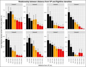
When I started to analyse vantage point survey data, I noticed a curious, but maybe not surprising, pattern: a lot of flightlines clustered close to the vantage point and a lot of white space with no flightlines in the more distant parts of the viewsheds. My investigations of this pattern have shown that there are usually very strong distance effects on detection rates with very low detection rates at distances of more than 1 km from the vantage points, as shown in Figure 1. Correcting for under-detection of distant flightlines can increase collision risk estimates by factors of around 1.5 – 6 times.

Figure 1. Detection rates during vantage point surveys showed strong declines with distance from the vantage points in the eight datasets analysed.
While the implications of the distance effects for collision risk predictions are obvious, there are also more subtle implications for the design of vantage point surveys. It is common practice for many vantage points to be located some distance outside the wind farm site, taking advantage of the 2 km maximum viewshed radius allowed by the SNH guidance. This often allows better viewshed coverage in typical upland wind farm sites with rugged terrain and extensive forestry, compared to vantage points located close to, or within, the sites. However, this means that, due to the distance effects, most of the flight activity detected will be outside the wind farm site. This may give false impressions of low use of the site by bird populations of concern and can cause further biases to the collision risk modelling.
Survey effort
The 36 hours standard was introduced in the first published version of the SNH guidance that I have seen, dating from 2005, and has been repeated in the three subsequent revisions of this guidance. However, despite the hundreds of thousands of hours of vantage point survey data that must have accumulated since 2005, this standard does not seem to have been tested against empirical data. In fact, the only published test of the effect of survey duration on collision risk estimates suggested that 36-hour samples could produce quite wide variability in collision risk predictions[2].
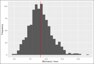
I have been developing a simulation modelling approach to investigate these issues. My preliminary modelling indicates that, when flight activity is more or less randomly distributed, 36-hour surveys can produce reasonably representative samples (Figure 2). However, when there is seasonal, daily, or diel aggregation of flight activity, longer durations and / or more complex distributions of survey effort will often be required. As previously noted[2], consideration of the probability distributions generated by sampling effects also raises questions about the level of certainty required for collision risk predictions.

Figure 2. Distribution of Whooper Swan flight activity rates recorded by 1000 replicate 36-hour watches from a simulated dataset, compared to the overall Whooper Swan flight activity rate in the dataset (shown by the red line). The collision risk is proportional to the flight activity rate and was 0.2 collisions / year in the vantage point survey dataset that was used to parameterise the simulated dataset.
Implications for guidance
The work that I have briefly outlined above, and which I will be presenting at the CIEEM 2024 Irish Conference, highlights some important issues with the way that the SNH guidance has been used to set standards for wind farm ornithological assessments in Ireland. Over-reliance on a checklist approach to compliance with the guidance affects both the practitioners of the assessments and the competent authorities who review the assessments. In fact, the SNH guidance is more sophisticated than a simple checklist of survey requirements: for example, it defines the 36-hours standard as a minimum, rather than a target, and it includes discussion of distance effects and other potential biases.
Guidance is important in setting standards and creating a level playing field for all sides involved in wind energy projects. However, specific guidelines should not be seen as set in stone and should be subject to review and revision as knowledge develops. The CIEEM’s Principles of Preparing Good Guidance for Ecologists & Environmental Managers[3] recognises the importance of evidence-based guidance and carrying out research and data gathering to fill gaps in the evidence base. The huge expansion in wind energy ornithological work in Ireland in the last 10-20 years has generated large volumes of data that could be used to carry out empirical tests of key aspects of the relevant guidance. It would be in the interest of all parties involved in wind farm developments to take advantage of this resource to develop guidance that has a stronger evidence base.
Tom will be presenting his research at our 2024 Irish Conference.
[1] SNH (2017). Recommended bird survey methods to inform impact assessment of onshore wind farms. March 2017. Scottish Natural Heritage. www.nature.scot/doc/recommended-bird-survey-methods-inform-impact-assessment-onshore-windfarms.
[2] Douglas, D. J. T., Follestad, A., Langston, R. H. W., & Pearce-Higgins, J. W. (2012). Modelled sensitivity of avian collision rate at wind turbines varies with number of hours of flight activity input data. Ibis, 154(4), 858–861.
[3] https://cieem.net/resource/principles-of-producing-guidance.
Tom Gittings is an independent ecological consultant with 28 years’ experience in professional ecological consultancy work and research. He has specific expertise in ornithological assessments for wind energy projects. A major focus of his work is collision risk modelling. He sees the large datasets that are collected during vantage point surveys as providing a variety of opportunities for sophisticated data analyses and has been developing collision risk modelling techniques that extend the standard model used for onshore wind energy projects.
Blog posts on the CIEEM website are the views and opinions of the author(s) credited. They do not necessarily represent the views or position of CIEEM. The CIEEM blog is intended to be a space in which we publish thought-provoking and discussion-stimulating articles. If you’d like to write a blog sharing your own experiences or views, we’d love to hear from you at SophieLowe@cieem.net.
