Let’s Get Digital! An Outsider’s Guide to Field Data Capture – By Ben Pleasant
BLOG
For sustainability advocates we sure do waste a lot of paper! Whether it is printing off hard copy maps or forms for field data collection, many environmental surveyors still look to the humble tree for their work, despite the digital age we now live in… But why?
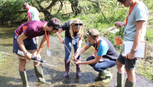
Looking for evidence, I did a Google image search for ‘fieldwork’ and this is the first picture that comes up. 
This is from the Royal Geographical Society’s school resources on GCSE fieldwork… Exhibit A, Your Honour!
This is how we are taught at school. Then we head to university, where paper-based techniques are reinforced, and finally we are into the working world, at which point we do what we know – which is only natural.
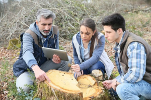
 Back to my Google search and a full 67, almost identical, images later I found it… a picture of modern fieldwork – Exhibit B!
And the source of this? Last year’s Enhancing Fieldwork Teaching event from the British Ecological Society.
I appreciate how perfect these two examples seem, but I promise you, I’m not making it up!
It’s easy to see why the environmental sciences still cling to paper-based methods for their work. When you ask most people to picture ‘fieldwork’ in their mind’s eye, you can pretty much bet they are imagining what you see in that first image.
The Digital Revolution
In the last 20 years we have seen some huge leaps forward in technology. Back in 2001 (yes it really is that long ago!), we saw the first iPod, a revolutionary new media player which, let’s be honest, is now nearly obsolete thanks to today’s smartphones.
The world of software has been no different and we now have data recording capabilities which, back in 2000, were not possible, let alone affordable.
Modern Geographic Information Systems (GIS) have evolved from purely systems of record, where users would convert paper-based data into a digital equivalent for storage and reference, to systems of insight, where data is collected digitally and instantly distributed to relevant individuals for further analysis and interpretation.
Today’s GIS platforms allow for:
- First-time digital data collection in the field
- More accurate, precise results
- Faster data acquisition
- More efficient workflows, allowing more surveys to be completed in less time
- Reduced or zero need for editing surveys back in the office
- Faster, more interactive, self-serving applications supporting instantaneous operational feedback for managers
Despite these new capabilities, some environmental surveying companies are still not modernising their surveying techniques and I have found this is primarily down to a set of…
Common Misconceptions
In my time working with ecologists and environmental consultants, I have come across a series of common misconceptions which have blocked individuals or organisations from modernising their workflows.
Online platforms mean I must be connected to the internet, but I work in areas with limited or no connectivity.
This one I hear quite a lot and fortunately the answer is brief. Any good data collection application will not only be widely available across different devices, but also have an offline mode which allows the user to synchronise any changes made in the field once they get back to the office or home.
I won’t be able to learn how to use the software.
One of the most common reasons I’ve heard for not modernising surveying methods is a lack of digital readiness in a company. This is often driven by individuals within the organisation who have many years’ experience of collecting data in a certain way. Individuals can feel daunted by the learning curve of implementing new techniques.
Fortunately, modern GIS systems allow for a range of users with varying experiences and capabilities. Some users will be the main content creators and distributors, while others can focus their time on fieldwork, only needing easy-to-use apps that require little to no training. It has never been easier to get started!
I can’t afford to change the way we currently work.
Finally, and arguably the most substantial obstacle organisations face, is the cost of change. This is not only the cost of any software licenses, but also the time spent to implement systems and educate the workforce, as we have already touched on.
There will always be some cost to change, which is sometimes difficult to measure, but the great news is that today’s GIS systems are not only more affordable than ever, but are also easier to implement and faster to bring all the team up to speed on. It can take as little as half a day to get fully up and running with a new GIS system and, once you have the workflows in place, you’ll be able to complete tasks faster and take on more projects than ever before with the same team.
These benefits ensure that any initial outlay will be more than made up for in the medium to long term. So rather than, ‘Can I afford to do it?’, the question should be, ‘Can I afford not to?!’
In the last few years I have been lucky enough to see ecologists and environmental consultants transform the way they work first-hand. For me, the most rewarding part of the journey is seeing the renewed passion for their work that these teams show when they have a system that enables them to do their job better than ever before. I look forward to more of the same in 2020.
So, the next time you find yourselves asking the question, “Should we go digital?” Surely the answer’s on a postcard… Although hopefully not literally, let’s not waste more paper!
 About the Author:
Ben works for leading GIS provider Esri and has been working with ecologists and environmental consultants over the last few years to help them move from paper-based workflows to fully digital systems. You may have previously seen his blog on Phase 1 Surveys or the webinar Esri gave on their application for Phase 1 surveys. Ben and his colleagues will be exhibiting at CIEEM’s upcoming Spring Conference, where they will be available for discussion and providing demonstrations of the latest surveying techniques.
Blog posts on the CIEEM website are the views and opinions of the author(s) credited. They do not necessarily represent the views or position of CIEEM. The CIEEM blog is intended to be a space in which we publish though-provoking and discussion-stimulating articles.
